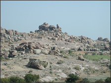
During its first field season at
Vijayanagara, Archaeos' surveying team focused on documenting
structural remains along the area known as the 'North
Ridge'- a topographical feature more than two kilometers
long and about half a kilometer wide, that separates the
'Royal' and the 'Sacred' precincts of the city’s
urban core.
In their initial two-month period,
the team concentrated mainly on the southwestern end
of this ridge - an area chosen because of the high density
of architectural remains there, including at least one
palace-like structure visible on the surface.
In addition, for the purpose
of comparison to what seems to be a palace on the North
Ridge, the team collected enough data to create a 3-D
model of a palace structure in the 'Noblemen's Quarter,'
an area southwest of the North Ridge that has been partially
reconstructed by local archaeologists. By the end of
the first season, an area of approximately 50,000 sq.
m had been mapped.
Learn more about
the project and the first season (2000-2001)
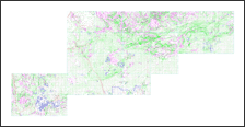
One of the results of the 2003 field season was the
completion of tracing and digitalization of the Vijayanagara
Research Project's 1:400 maps-created in the 1980's
under the direction of Dr. John Fritz-into a CAD (Computer
Aided Design) format. The digitalization of the maps
relevant to the survey area of the Archaeos Mapping
Project at Vijayanagara means that we will now be able
to model 3-dimensional topographical data in order to
show how it correlates to the architectural surface
features that we have been mapping.
The primary focus of Archaeos' surveying along the
North Ridge of the City during the 2003 field season
was to map large portion of the southern face of the
major fortification wall along the ridge's North side.
This task is important for two reasons: 1) to delimit
a fixed perimeter for the remaining portion of the survey
area along the western portion of the North Ridge; and
2) to define a large accurately mapped feature that
corresponds directly to a visible feature on the older
VRP 1:400 maps. The importance of this second task is
that it will allow us to accurately "key-in",
or overlay, our newer maps-which show only man-made
features-onto the topographical features of the VRP
maps. It also serves as one form of determining the
accuracy of the earlier maps, which were hand drawn
using a much earlier form of optical surveying.
In addition to the continued surveying along the North
Ridge, a large percentage of our effort in that area
was directed towards further documenting features discovered
during the previous seasons by means of an intensive
campaign of digital photography that included both ordinary
"still-shots" and 360-degree panoramic view
that are "stitched" together using the computer
by means of QTVR (Quick Time Virtual Reality). These
panoramas are an important form of documentation because
they are extensive and interactive in nature; they allow
the viewer to move through space on the computer panning
and zooming in and out on any particular feature within
the circumference of the original camera's view. We
have now completed and modeled QTVR shots from all of
our surveying stations, which means that they visually
cover the entire completed survey areas on the North
Ridge, as well as in the Noblemen's Quarter.
Approximately half of the field season was directed
towards continuing to map the buildings within the Noblemen's
Quarter.
2003
Progress Report - American Institute of Indian Studies
(AIIS)
The second season's work continued
with data collection from the surface of the North Ridge
and the Noblemen's Quarter. Approximately another 50.000
sq. m was mapped and more information about the Royal
Center's economic and social activity was revealed.
In particular, the expanded maps of the North Ridge
produced each evening began to yield a clearer picture
of Vijayanagaran life in this area. Analysis shows that
this now desolate-looking and unprotected area was in
no way marginal: it was, in fact, once an active and
thriving part of Vijayanagara’s urban core. The
numbers and massings of the architectural and other
cultural remains along the surface of the North Ridge
indicate dense urban development and can give more clues
as to the settlement patterns and spatial layout of
the city.
2002
Progress Report - American Institute of Indian Studies
(AIIS)
|