Projects : Built Heritage, Urban Planning, & Cartography
Vijayanagara Mapping Project
Season 1: December 10, 2000 to February 12, 2001

General Overview
From December 2000 to February 2001 Archaeos conducted a project mapping and analyzing the historical uses of urban space at Vijayanagara, the capital of the southern Indian empire of the same name during the 14th — 16th centuries. The project was co-directed by Archaeos' David Gimbel and by John M. Fritz of the Vijayanagara Research Project (VRP). The initial two month field season focused on documenting structural remains along the area known as the ‘North Ridge' a topographical feature more than two kilometers long and about half a kilometer wide, that separates the ‘Royal' and the ‘Sacred' precincts of the city's urban core. Additional project members included Andrew K. Y. Leung (Assistant Director), Ian Stell (Assistant Surveyor) and Jessica Glass (Cinematographer). In New York, Stephanie Tayengco and Paul Zimmerman were both responsible for writing and modifying different portions of computer scripts designed to manipulate and import data from the surveying software to the CAD program.
The Central City of Vijayanagara originally consisted of a fortified royal residential quarter and a series of bordering temple-centered religious communities that occupied an area of approximately 20 square kilometers. The larger Metropolitan Region surrounding the Central City extended to an area of approximately 550 square kilometers. Although Vijayanagara is a site of extraordinary cultural and religious significance, its preservation is currently under pressure from various forces including tourism, farming, and a growing local population. Vijayanagara is a UNESCO World Heritage Site — the first such site in India to be officially declared endangered.
Although now denuded of the majority of structures that once covered most of its area, the North Ridge's significance has long been indicated by the fact that one of Vijayanagara's most important roads cuts directly through it connecting the Royal Center with the rest of the Central City. The North Ridge is lined with temples and other structures including palaces and elite complexes which were protected by walls and fortified gateways. Fortunately, remains of structural walls are still highly visible along many of the slopes on the North Ridge despite the fact many ancient building materials have washed down from the surrounding hillsides and now obscure many of the original buildings and other features along the valley floor.
On the ridge, roads, paths, small temples, several palaces, other elite complexes, and structures of unknown function are indicated, not only by the remains of rubble walls, but by numerous other diagnostic features cut into the rock — anchor holes, door pivots, and areas that have been chiseled away to function as wall and column seatings. Nearby rock outcrops also bear remaining traces of numerous domestic features including mortars, ties, sockets for wooden structures, and rock cut game boards. During its first field season at Vijayanagara, Archaeos' team concentrated on the southwestern end of this ridge — an area chosen because of the high density of building remains there, including at least one palace-like structure visible on the surface. By the end of the season, the team had mapped an area of approximately 40,000 square meters.
Project Background
Since 1980, the Vijayanagara Research Project (VRP), an international consortium of scholars, working in cooperation with Indian archaeologists, has been documenting the visible surface features of the central city. Although it is rare that the layout of extinct cities can be observed on their surface, at Vijayanagara it is possible to document not only routes of movement, but the distribution of buildings, domestic facilities, fortification walls, and gateways using techniques of surface archaeology that include surveying, drawing, photographing, writing descriptions, and compiling databases.
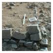
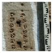
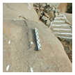
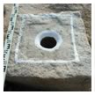
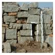
From left to right: corner of wall remains, mankala type gameboard, wall seating in bedrock with stair behind, bedrock mortar, drain through a wall
Working with a team of Indian surveyors during the 1980s, the VRP mapped the topographic and cultural features of the city center at a scale of 1:400. VRP's 1:400 mapping program provided extensive coverage of the central city's features, effectively showing the density, extent, and approximate form of structural remains over an area of some 1100 hectares. Over a period of more than two decades, VRP has produced a series of architectural drawings and photographs documenting all of the major monumental buildings within the Central City and compiled a database that contains entries on approximately 31,000 cultural features.
(Drawing courtesy of the Vijayanagara Research Project)
VRP's architects and archaeologists have also documented a great number of specific ruined structures at a more accurate scale of 1:100 or 1:200 by using traditional methods, such as measuring with hand-held tapes. In the case of the more illustrious temples and royal building projects at Vijayanagara, the VRP was able to overcome the inaccuracies of using hand held tapes by employing an engineer to locate specific coordinates using a transit — a mechanical surveying instrument that is used to take angle measurements of highly accurate measurements which were then correlated with hand taken measurements in order to map the buildings' ground plans. Such techniques are time-consuming, however, and have historically been proven unreliable over large distances.
Although the use of surveying instruments such as transits allows archeologists and architects to attain a high level of precision, their use at Vijayanagara has not been extensive. The form, components, and spatial relationships between many of the site's less magnificent but equally historically significant remains have not yet been as precisely recorded and displayed as is now possible with more modern surveying technology and the proliferation of affordable computers. Recognizing this, in early 2000 John Fritz from the VRP began discussing co-directing a mapping project with Archaeos' David Gimbel using technology similar to that employed by Archaeos at Tell Arbid in 1999.
Archaeos' current project at Vijayanagara is intended as an extension of the VRP's extensive two-decade-long documentation process, as well as an initial analysis of the principles of urban planning and the historical uses of space within a heavily destroyed area of the ancient city. By utilizing state of the art surveying technology, Archaeos has been able to bring a greater degree of accuracy to the ongoing documentation process.
Methods and Results
Archaeos' season mapping the North Ridge at Vijayanagara was conceived of as a test project. One of its aims was to see what differences new technologies of mapping could bring to augment the methods being used by the Vijayanagara Research Project. Another was to see if the study of previously unmapped areas would bring information that would significantly alter the previous views of the settlement patterns or spatial layout of the city.
Prior to the field season, John Fritz of the Vijayanagara Research Project (VRP) suggested the North Ridge as the focus of the joint project. Because the ridge is more than two kilometers in length, the first step upon arriving at the site was to spend several days walking along the entire ridge in order to select a manageable area of approximately 25,000 to 50,000 square meters, given the length of the season and the size of the surveying team.
Map generated with CAD (computer assisted design program) showing area surveyed by Archaeos and the VRP during the last season. Click on map inset for an enlarged view of that area with a panorama, photographs of the site, and examples of the types of archaeological features being recorded.
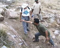
David Gimbel, John Fritz, and Andy Leung selected an area along the south-western end of the North Ridge. Subsequently, teams of workers were hired to clear any dense vegetation from the area that might hinder the surveying process. Gimbel and Leung set up the main traverse while John Fritz and several of his assistants marked as many surface features as possible. The features were marked with a white paint made of white lime that will wash away after one or two rainy seasons, thus avoiding any permanent damage to building features or other cultural artifacts.
After the features to be surveyed were marked, points describing walls, anchor ties, door pivots, lamps, and numerous other cultural features were "shot", or recorded, with a total station. Data from each individual point was automatically recorded in a hand-held computer, a Psion with Prosurv software. For each point, the operator of the total station also entered additional information about each point called a ‘control code’. This information would be used to automatically plot each point in three dimensions relative to other surveyed points in Vector Works, a CAD (Computer Assisted Design) program. Depending on the ‘control code’ chosen, the point would be marked as an individual point, drawn as part of a line, or as part of a closed polygon.
The information about each point was stored in the form of a database. Aside from coordinates in three dimensional space and the way the point should be handled relative to others, recorded information for each point included the category of object being surveyed, the object’s composition and its state of preservation. This was handled through ‘feature codes’ also entered by the total station’s operator. The ‘feature codes’ are individual codes describing designations devised by John Fritz and David Gimbel and then programmed into the data collector as choices in its menu system. For example, an individual point might contain feature code information describing it as a "bedrock mortar" with a "diameter 15cm" and a "circular surround"; or an "anchor hole" whose "contents" are a "stone peg". Upon returning to the camp each day data was downloaded from the Psion onto notebook computers, inspected for errors, then imported into VectorWorks and plotted onto Archaeos’ maps.
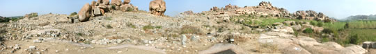
Although at first the area which was chosen looked like an abandoned ridge, the mapping process has already begun to yield a very different picture of the North Ridge. Once the new maps are analyzed it becomes immediately clear that this now desolate looking area was in no way marginal, it was, in fact, once an active and thriving part of Vijayanagara’s urban core. The numbers and massings of the architectural and other cultural remains along the surface of the North Ridge indicate dense urban development. The numerous mortars carved into the bedrock and used for processing foods, for instance, would have once been inside domestic structures and are evidence of household activity. Column seatings, anchor holes, and other features are carved into the rock surfaces of the North Ridge — these allow us understand and to map the density of structures in the area. Some of these features, such as the many sockets for door hinges indicate where the entrances of utterly obliterated buildings must have been. Many wall remains are still present; while in many instances the buildings are now gone, where they were originally constructed directly on bedrock the wall seatings are visible. It is even possible in some places to feel the difference in surface texture of the stone where high traffic areas have been worn. Once these many disparate features are mapped, they are more easily understood as the remains of coherent structures and indicators of economic and social activities.
Of particular interest within the surveyed area were several large buildings that were included in the VRP’s earlier 1:400 survey maps. One of these had also been measured and drawn previously using hand held tapes; it is an elite compound whose function is not completely understood. The second major building within the survey area has never been drawn previously and should be classified as a palace as it its ground plan now shows it to be comparable in layout to similar buildings within the area known as the Nobleman’s Quarter — an elite residential district. These, along with the other various remains in the surveyed area suggest that far from being an isolated area, this was a highly populated one with elite inhabitants. With the permission and support of H. T. Talwar, the Deputy Director of Museums and Antiquities of the State of Karnataka, Archaeos’ team was also able to three-dimensionally map an area of the Nobleman’s Quarter for comparison to the palace on the North Ridge.
Over the last 20 years, standing structures and major parts of Vijayanagara have been mapped and drawn, however, areas not previously acknowledged to have archaeological remains still need to be mapped to fill in the incomplete picture we have of the city. As projects like the collaboration between Archaeos and the VRP continue to research and survey at Vijayanagara in future seasons, it becomes possible to reach a better understanding of the layout of the city and its functions.
View the results of the second field season (2002)Women clearing an area near a small temple
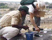
Above and below: Selecting and marking cultural features to be surveyed
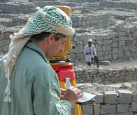
Surveying in the Nobleman's Quarter
Map of a palace in the Nobleman's Quarter.