Projects : Archaeology, Anthropology, & Living Cultures
Preliminary Site Report of the Oriental Institute of the University of Vienna and Archaeos Excavation Project at Tell Arbid, Sector D°
Summary
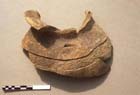
The Oriental Institute of the University of Vienna and Archaeos, Inc. collaborated in a joint archaeological research project at Tell Arbid in the Jezireh region of Syria between 31 August 1999 and 9 September 1999. The excavation opened eight separate areas, three in what is referred to here as the 'southern operation and five in the 'northern operation'. The 'southern operation' did not uncover any substantial architecture, possibly because dirt and debris eroding for millenia had been deposited in that area, a trough like depression at the side of the tell. A 'northern operation' was staged in an area thought to be outside the original city fortifications. The areas in this operation yielded a series of architectural levels and burials, most dating to the Early Dynastic period (specifically ED III, 2600-2350 BCE.) Among the architectural finds were a building with the remains of impressed door sealings situated in one of the rooms and outside the structure. These sealing suggest a possible administrative function for both that particular building and several other structures within the same complex, which included a courtyard with grinding stones still in situ. Many other objects were also unearthed during the season including: cylinder seals, and various types of pottery, animal and human figurines, as well as bronze pins and tweezers. Two later Hellenistic graves were also discovered. Both were undisturbed; the one in the best stage of preservation contained a wine jar, bronze drinking cup, and bronze serving ladle, wheras the other contained a vessel sculpted out of alabaster.
The participants
The Oriental Institute of the University of Vienna and Archaeos, Inc. (a non-profit organization dedicated to education and to archaeological research and based in New York City) collaborated in the joint archaeological research project at Tell Arbid between 31 August 1999 and 9 September 1999. The project was conducted in co-operation with the Faculty of History of the Warsaw University, but "operating autonomously from the archaeologists from Warsaw…exploring a previously unexcavated sector of the site i.e. the north-western corner of Arbid's citadel." (As stipulated in the "Agreement between the Oriental Institute of Vienna University and the Faculty of History of the Warsaw University about archaeological co-operation at Tell Arbid (Syria) in 1999", July 1999.) The Vienna/Archaeos excavation would ultimately include eight separate areas at Tell Arbid known as: D 32/44, D 32/45, D 33/46, D 30/43, D 29/43, D 29/42, D 28/43, and D 28/42. The excavation season was co-directed by Prof. Dr. Gebhard Selz (Faculty of the University of Vienna) and David Nelson Gimbel (Faculty of the University of Vienna, President of Archaeos, Inc. and member of Oxford University). The expedition's assistant director was Paul Zimmerman (Vice-President of Archaeos, Inc., and member of the University of Pennsylvania). Other members of the expedition included Doris Felsner, Katharina Wernisch, Gerhard Karner and Bojana Jancovic (all members of the University of Vienna).
The 'southern operation'
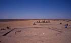
The original intention of the Vienna/Archaeos joint team was both to excavate several 10 X 10 meter trenches and to conduct a broad scale surface scraping of a larger area. It was hoped that whereas the scraping procedures (similar to those utilized successfully at the site of Abu Salabikh in Iraq) would allow the excavators to define and map the architecture within a large area-thus yielding information about at least one period of residential and/or the city planing at Tell Arbid, the excavation of several individual trenches or small-scale soundings would allow the architectural remains to be tied directly to a controlled stratigraphic sequence. With this program of research in mind six 10 X 10 meter trenches (D 32/44, D 32/45, D 32/46, D 33/44, D 33/45, and D 33/46) were surveyed and staked out. Scraping was then initiated in D 32/44, D 32/45, and D 33/46 (Plate 1). The initial results of the scraping, however, yielded no substantive architectural remains.
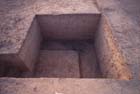
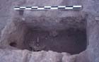
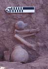
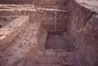
Both area D 33/46 and area D 32/45 were dug to a depth of approximately 1/2 meter below the surface with no substantial results. Area D 32/44 which was opened later than the other two areas was dug to a depth of approximately 20cm below the surface with no practical results. Because of the location of these three areas-in a topographically trough-like region set between the citadel and a rise that may have been part of the outer fortification wall-it was hypothesized that the reason that the area was so barren of any architecture was that it was covered by a large quantity of dirt and debris that had washed out from the slope of the citadel. It was decided that not only scraping, but probably any form of excavation in this area would be largely unproductive because of the tremendous quantities of earth that would have to be moved before reaching any form of architectural levels. Squares D 32/44, and D 33/46 were therefore closed and square D 32/45 was reduced in size to a 4 X 4 meter sounding in order to test the conclusions reached by the excavators thus far (Plate 2), (Plate 3), and(Plate 4). The sounding was dug to a level of approximately 215 cm below the surface and the results of its exploration can be summarized as follows:
- Approximately the first 20cm of earth consisted of typical "subsurface" debris composed of soil, roots, and pottery that is presumed to have eroded from the slope of the citadel.
- The following 20 to 25cm were composed of two layers of compacted earth-the upper layer being darker in color than the lower.
- The next 50 to 70cm of earth were largely 'sterile' and almost universally devoid of pottery sherds.
- Below the level just mentioned lay various layers with evidence indicating human habitation including lenses of ash, broken libn and a small amount of 'Khabur period' pottery sherds.
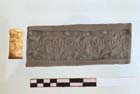
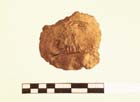
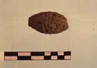
One interesting small find was discovered, although completely removed from any meaningful context: an ED IIIB cylinder seal carved of a hard, white marble-like material (Plate 5). Following the closing of squares D 32/44, and D 33/46, the focus of the Vienna/Archaeos team's excavations was moved to a section of Tell Arbid further away from the citadel and to the north.
The 'northern operation'
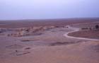
This new area was situated on a ridge with a rise on its southernmost portion that then sloped abruptly down to the north. These topographic features, in conjunction with the appearance of a large gap in the ridge-immediately to the east of the aforementioned area-suggested the possibility that the ridge may have been the city's original fortification wall and that the gap to the east may have represented the 'gate' leading in the direction of Urkesh (Tell Mozan). This hypothesis was also suggested by oral accounts of a 'wall' that was claimed to have been sighted by the villagers of Tell Arbid several generations earlier as well as by Max Mallowan's claim that he had once located the city wall, possibly in the area of his trench that was positioned along the same ridge, but to the east of the 'gap'. (The "gap in the ridge" is visible in (Plate 6), just in front of the area where the road curves in the background; the remains of one of Mallowan's test trenches are also partially visible on the far right hand side of the photo, about half way down where there is a small depression in the ground.)
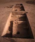
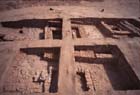
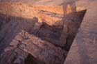
The excavations in the newly opened sector (seen together in (Plate 7)) included areas D 30/43, D 29/43, D 28/43, D 29/42 and D 28/42, all of which were opened in the order just mentioned. Although all of the areas were measured out and staked as 10 x 10 meter areas (i.e. 9 x 9 meter excavation areas with 1/2 meter baulks along each side), a decision was made to dig only 9 x 5 meter sections of areas D 30/43, D 29/43, and D 28/43 in order to investigate the stratigraphic sequence as it progressed down the slope of the hill. Sections of squares D 29/42 and D 28/42, measuring 4 x 4 were opened only in the final weeks of the excavation in order to further understand the architectural remains in the two squares adjoining them.
All of the areas investigated in the 'northern operation' yielded a series of architectural levels and burials, the majority of which dated to the Early Dynastic (ED) period (also known locally as the 'Early Jezireh', or 'EJ' period). Some intrusive materials from later periods were also present, particularly in D 30/43.
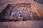
Area D 30/43
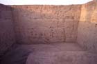
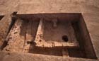
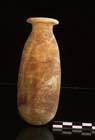
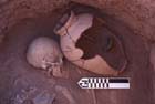
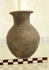
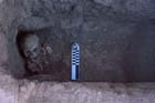
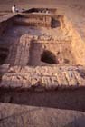
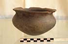
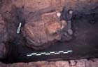
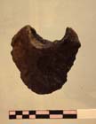
The southernmost part of Area D 30/43 (Plate 8) contained the remains of a large room whose walls were roughly oriented in the cardinal directions of the compass. The eastern wall of the room, which probably also included its entranceway was visible only in the baulk and a preliminary inspection of the ceramic finds associated with the structure indicate that it dates to the end of the ED III period. A small grave (known as 'Grave 3') dating to the Hellenistic period had been later dug into the northeastern corner of the building (Plate 9). It was surrounded by four mud brick walls and capped with an additional series of diagonally placed bricks. Although the burial appeared to have been undisturbed by humans, the skeleton was found to be in a very deteriorated condition. Only one grave good was found in association with the body, a delicately worked alabastron (Plate 10).
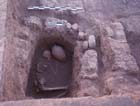
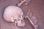
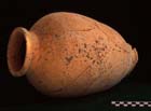
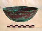
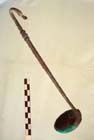
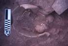
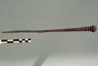
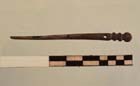
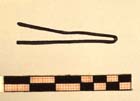
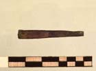
Along the northernmost portion of Area D 28/42 a wall was discovered running from the easternmost to the westernmost baulk of the trench. As in the case of the aforementioned building, a later, undisturbed Hellenistic grave ('Grave 2') had been dug into a portion of the wall (Plate 11), (Plate 12), and (Plate 13). Its method of construction was identical to that of 'Grave 3', but its contents and state of preservation were far more remarkable. 'Grave 2' contained a very finely preserved skeleton with a highly deteriorated silver coin that had originally been placed in the mouth (Plate 14). The burial also contained a wine jar (Plate 15), a bronze drinking cup (Plate 16) and a bronze wine ladle (Plate 17). A child burial ('Grave 1') was also discovered in a pit slightly to the west of 'Grave 2' but it had been heavily disturbed (or perhaps looted) and it contained no associated burial offerings.
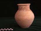
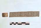
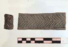
Two other graves were also discovered in Area D 28/42. Grave 4 (Plate 18), discovered along the center of the western baulk was disturbed to such an extent that only three bones were still remaining, however, two intact vessels (Plate 19) and (Plate 20), probably dating to the second millennium, were found in conjunction with the existing remains. Grave 5 (Plate 21) was discovered in the area between the northernmost baulk and the long wall running from east to west along the entire trench, in conjunction with a badly deteriorated and unidentifiable bronze object and two badly deteriorated shell objects that may have been 'eye coverings'.
The buildings and grave in the northern section of Area D 29/43
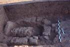
The northern section of D 29/43 contained portions of at least two buildings (one to the east and one to the west) with evidence of multiple levels of rebuilding (Plate 22). The uppermost levels of the buildings were composed of badly eroded brick; because they lay barely below the natural surface of the hill, only several courses of their bricks remained, but the ceramic evidence associated with them indicates that these levels dated to the later portion of the ED III period. A jar burial containing two skeletons of children was also discovered at approximately the same level, but near to the eastern baulk (Plate 23). At least two subsidiary levels of the building structures just mentioned were visible in sections subsequently dug along the southern and western faces of the easternmost structure, as well as the southern face of the western structure (Plate 24).
A series of burials, or perhaps a cemetery, must also have existed at a previous time in the same area since scattered bone fragments were found throughout all of Area D 29/43. The easternmost of the building structures mentioned also contained an intrusive shaft more than two meters in depth (Plate 25) towards the top of which some human bone fragments (known as 'Grave 1') were discovered. (Each area has its own individual sequence of grave numbers-e.g., D 30/43 'Grave 1' versus D 20/43 'Grave 1'.) The remains of a second grave ('Grave 2') were discovered at the bottom of the shaft in association with an ED III 'metallic ware' bowl (Plate 26). It is unclear what the purpose of the shaft originally was as it appears to have been filled with a mixture of ash and earth. It seems unlikely, however, that this was a 'shaft grave'. The shaft had, in fact cut through a brick wall and incised Ninevite V pottery sherds were discovered towards the bottom of the shaft. It seems more than likely that the burial at the bottom ante-dates the shaft and that whomever cut the shaft burrowed down upon the earlier burial by chance.
The southern part of Area D 28/43, the northern part of Area D 29/43 and Areas D 29/42 and D 28/42
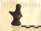
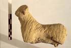
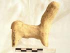
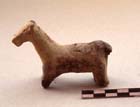
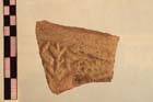
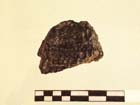
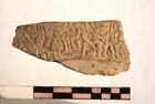
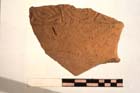
Evidence of extensive burials, now largely destroyed by erosion or theft were found throughout the uppermost portions of Area D 29/43, the majority of them being in the southernmost part of the square. Many objects were therefore recovered 'out of context', among the most interesting being two bronze pins found in separate locations (Plate 27) and (Plate 28), a set of bronze tweezers (Plate 29) and (Plate 30), and two geometrically incised cylinder seals (Plate 31) and (Plate 32) the latter of which was crafted from 'glazed steatite' and was of a style commonly associated with a much earlier period (i.e., ED I). Area D 29/43 also contained a human figurine (Plate 33), a large number of animal figurines, the original contexts for which remain unknown (Plate 34), (Plate 35), and (Plate 36), and an unusual sealing depicting two snakes and plants that had been impressed upon the surface of a ceramic vessel (Plate 37).
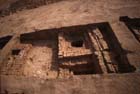
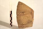
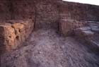
The southern part of Area D 28/43, the northern part of Area D 29/43 and Areas D 29/42 and D 28/42 are discussed in conjunction here because together they contained the remains of a quadrangular building (Plate 38) that overlapped all four of these excavation squares and which can all be securely dated to the Ninevite V period based upon the style of the incised pottery sherds associated with it. The portion of the building's interior positioned along the southern baulk of D 29/43 contained a wall-like structure, only one brick course in thickness, the purpose of which is unknown. The proximity of this structure to both the baulk and to the southern wall of the building made it impossible to excavate that portion of the room any deeper, though the future removal of the baulk would, no doubt, clarify the purpose of this construction. Within that same area of the building a door-sealing was discovered, the remaining portion of which depicted the legs and lower torso of a seated figure (Plate 39).
The portion of that same room on the northern side of the baulk in area D 28/43 was remarkable in that its southern wall was composed of alternating courses of red and grey colored bricks (Plate 40). In that same section of the room, a disturbed burial was discovered that must have post-dated the building's abandonment since it was located well above the level of the extant floor (Plate 41). A small jar and a bowl securely date the grave to no later than the first half of the ED III period, serving as a terminus ante quem for the construction of the building. A series of important small finds discovered in the exterior area to the south of the building suggests that administrative functions may have occurred in or near this area. These finds included: a bulla (Plate 42), two sealing fragments that appear to have been used to secure doors (Plate 43) and (Plate 44), and sherds of fired ceramic vessels, the surfaces of which had been impressed with sealings (Plate 45), (Plate 46), (Plate 47), and (Plate 48).
A narrow alley to the east of the building separated it from a structure, the wall of which ran parallel to the trench's eastern baulk. The alley was filled primarily with a deposit of fine grey ashes that had been mixed with some sherds of incised Ninevite V pottery. Below the ashes, a narrow 'U'-shaped enclosure (Plate 49) composed of libn had been constructed for purposes that are not clear.
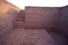
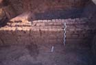
To the west of this same building, in area D 28/42, a narrow street originally provided one route of circulation between the structure just discussed and a second building to a courtyard-like space, also in area D 28/42 (Plate 50). This street was filled at a later date with a deposit of Ninevite V and other ED pottery sherds that formed a series of solid layers approximately a meter in height (Plate 51). The courtyard contained a series of grindstones, still in situ, and was defined by the walls of two additional other buildings along its western and northern sides. Only one wall of the westernmost of these buildings was excavated. Of the southernmost building, portions of two walls were excavated. The first wall ran parallel to the western baulk of D 28/43. At its eastern end the wall formed a bonded corner with a second wall that ran almost parallel to the southern baulk of D 28/42. The courtyard described above was also accessible from the east where there was no building structure, but where a prepared street/surface covered with pottery sherds and earth existed.
Conclusions
Unfortunately, because the excavations in areas D 29/42 and D 28/42 were initiated toward the end of the excavation season, they were each limited to an area of four by four meters in each trench. Nothing else is known about what must definitely be a far more substantial building complex. Future excavations in the area and vicinity of what has been referred to here as the 'northern operation' would undoubtedly yield additional and valuable information about the Ninevite V (i.e., ED) period building complex.
Additionally, even earlier building phases exist underneath the levels described here. In the extreme southern portion of area D 28/43 four walls pertaining to an earlier strata were discovered. Three of these were composed of courses limited to one brick in thickness. Of those three walls, two abutted to form a right angle in the trench's northwestern corner. The third wall appeared to run directly underneath one of the building structures described above and a fourth wall running from north to south and extending from the center of the northern baulk also appears to have belonged to a level prior to the construction of any of the other buildings in D 29/43, D 28/43,D 29/42 and D 28/42. An extended exploration of these earliest levels would provide scholars with a better understanding of the development of architecture and urban planning at Tell Arbid during the ED period.